|
Michael McFadyen's Scuba Diving - The Arch
The coast of NSW has at least four dive sites called The Arch, of which three are on the South Coast. The most famous of them is the one at Jervis Bay and another is located further south at Batemans Bay. The third on the South Coast is to be found at Shellharbour, just south of Wollongong.
The Bass Point Reserve is one of a number of dive sites in the Shellharbour area which are regularly dived by Sydney divers. Located only 105 kilometres south of the centre of Sydney (no more than one and a half hours drive from most spots) on the southern edge of Wollongong, Shellharbour is very popular with divers, especially those from the southern and western suburbs of Sydney.
The most popular dive sites are found in or off this reserve which is just to the south of Shellharbour township. Most of the divers who come here just dive the shore sites. These include Bushrangers Bay, The Gutter, The Gravel Loader and Beaky Bay as well as the remains of the ships SS Cities Service Boston, Alexander Berry and Our Own. Note that since December 2001 the council has been closing the whole Bass Point reserve (as well as some parts outside) during periods of Total Fire Ban. Ridiculous!!! (Note that I am a professional bush fire fighter so I think I can comment on this decision).
One of the harder shore dives is The Arch, but it is a much easier boat dive. Its difficulty comes from the fact that it is a longish walk to get to the entry/exit point, or you have to do a long swim from Bushrangers Bay and the entry/exit point is accessible only in millpond seas.
From Sydney, travel to Shellharbour by following the southern tollway south from Waterfall, past the Wollongong and Port Kembla exits to its very end at Albion Park. Continue along the Princes Highway past the new interchange (under construction mid-2001) for a few hundred metres until you reach the top of the first small hill. Turn left over the railway line and then right. Follow the road and signs and you will see Bass Point and the gravel loader in the distance. Down by the huge Shellharbour Workers Club, the road takes you into the town's main street. Prominent signs lead you to Bass Point Reserve. The area's two (three? - it keeps changing) dive shops are located in the main street. I can recommend Coastwide Diving for service and price for your airfills. They are located at the top of the street.
The best way to dive The Arch is by boat. The dive operators at Shellharbour run out here. If you take your own boat, launch it at Shellharbour and go out past Bass Point. Beware of the shallow reefs the extend to the north and west from the point. Once past Bass Point Island, travel about 150 metres past the entrance to Bushrangers Bay. You will see the two white marks and a flat vertical rock. This marks the location of The Arch. A GPS Reading 34° 35.9780' S 150° 54.1201' E (using WGS84 as a Datum) will put you right near The Arch. There is generally a mooring near The Arch. Sometimes it is on the eastern side but at other times it has been on the western side. Follow the directions earlier to explore the area.
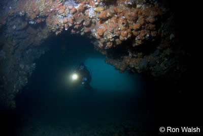 |  |
| Peter Flockart in The Arch - Photos by Ron Walsh | |
If you are doing The Arch as a shore dive, follow these directions. You will see the gravel loader as you approach the reserve. Just past the loader is the entrance to the reserve. Follow the dirt road for a kilometre or two until you see a parking area on your left. Turn right and park at the very end of the southern-most carpark. Before gearing up, walk along the old road that runs from the southern end in an easterly direction. After 100 metres or so cut across the rocks to the south, taking the easiest route. Once you get to the edge, have a look back at the rocks higher up and you will see two white marks painted on the rock. These two marks shore the eastern and western edges of The Arch.
 |
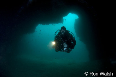
| On the wall outside The Arch - Photo by Ron Walsh |
After checking out the seas and the entry exit points (pick the best you can find), gear up, walk to the entry spot you have chosen and enter the water. Swim out a bit before descending. Drop to the sand and you will be in about 26 metres. Depending on whether you entered east or west of The Arch (based on the marks), swim in the direction of The Arch. The Arch itself is at right angles to the shoreline and located on a ridge that runs at right angles from the shore to the sand. The tunnel under the Arch is parallel to the shore. The Arch is quite large, about 20 metres long, 10 metres wide and three to five metres high. The bottom is sand. Once through The Arch, you can swim along the ridge and around the point back to the spot where you first entered it. On the western side, a bit shallower at 18 metres and around the next ridge ("point"), there is a largish cave. This cave has two chambers, the right hand one being smaller but deeper. There are often Port Jackson sharks here in Winter and a huge bullray often "guards" the entrance.
Once you have examined the cave and The Arch, you can explore a bit. However, I would always keep a fair bit of air in reserve. It does not take much for the wind to come up, make the seas rough and hence make the exit very difficult. If once you surface and it appears to be too dangerous to exit at the location selected, descend and swim east along the wall and eventually go into Bushrangers Bay. You will probably not make it all the way to the head of the bay, but there are many spots to safely exit on the southern side.
This is an excellent shore dive, but quite difficult. I would only recommend it for experienced divers. As a boat dive, it is a lot easier. It is not as good as The Arch at Jervis Bay, but it is still very good.
If you are going to dive Bass Point as a shore dive, I suggest taking a picnic or BBQ lunch (there are excellent BBQs here) and resting after your first dive on the grassy area. There are toilets but no water so bring all you need. A great spot for a relaxed, family double dive.
|  v6.00.307 © 2003-2005

